Palm Springs Aerial Tramway
Palm Springs Aerial Tramway / Mt. San Jacinto Wilderness Hiking
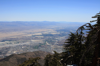
The Palm Springs Aerial Tramway takes you out of the summer heat in the desert up the sheer cliffs of Chino Canyon to a hiking paradise that is about 30 degrees cooler than the valley floor. It is a 10 minute ride from the Valley Station – elevation 2,643 ft. to the Mountain Station – elevation 8,516 ft. You can purchase a Summer Pass which allows you to ride up the tram as many times as you want from May 1 to August 31, which is well worth the price.
If you are ready to experience some of the most beautiful hiking the Palm Springs area has to offer, grab your CamelBak, ![]() other Hydration Pack
other Hydration Pack![]() or Hydroflask
or Hydroflask![]() and get out on the trail!
and get out on the trail!
The Palm Springs Aerial Tramway takes you up to Mt. San Jacinto State Park which offers about 54 miles of hiking trails located within the 14,000 acre Mt. San Jacinto Wilderness area. All of the trails are accessed by exiting the Mountain Station and descending a concrete pathway less than a mile lont to Long Valley. In Long Valley there are picnic tables, water, a Ranger Station, flush toilets and some easy trails. Or you can tackle some of the other more difficult trails like the Round Valley trail, Wellmans Divide Trail, or you can get real brave and do the San Jacinto Peak Trail.
Palm Springs Aerial Tramway Photo Gallery
![]() View photo gallery of the tram from May 2011
View photo gallery of the tram from May 2011
Trails in the Mt. San Jacinto Wilderness from the top of the tram
Long Valley Discovery Trail: Follow the nature trail posts around a 3/4 mile (1.2 km) loop. This easy level trail provides an excellent introduction to the Park's plants and animals.
Desert View Trail: A 1.5 mile (2 km) loop trail that leads to a number of scenic overlooks and forest views. Short climbs, moderately strenuous.
Round Valley: A hike of about 2.5 miles one way that leads to picturesque Round Valley. Fairly level trails, short climbs, moderately strenuous. You can also hike the Round Valley loop which is a moderately strenuous hike of about 5 miles. As you leave the Long Valley Ranger Station you will see the sign that points you in the direction of most of the hikes, including the loop trail. The loop trail is easiest if you follow the trail to the right when you get to the sign behind the ranger station. The way to the left starts to climb almost immediately and is more difficult. Read more about the Round Valley Hike here ... | Round Valley Hike Photo Gallery | Round Valley Loop Hike Photo Gallery
Wellmans Divide: From Round Valley to Wellmans Divide is a 1-mile hike (2 miles round trip from Round Valley, and 6.77 miles round trip from the tram station) with a 600 feet elevation gain which will bring you up to 9,700 feet. The view from here is truly spectacular. Looking west you can see the dome of the Palomar Observatory and to the southwest Tahquitz Peak Lookout. From this point you can continue down to Idyllwild or up to the Mt. San Jacinto Peak. Elevation gain, strenuous. Read more about the Wellmans Divide hike here ... | Wellmans Divide Hike Photo Gallery
Round Valley Loop: The Round Valley loop is a moderately strenuous hike of about 4 miles. Shortly after you leave the Long Valley Ranger Station you will see the sign that points you in the direction of the loop hike. The hike includes fairly level trails, short climbs, and is moderately strenuous. Read more about the Round Valley Loop hike here ... | Round Valley Loop Hike Photo Gallery
San Jacinto Peak: This is a 5.5 mile hike one way that will take you to the second highest point in southern California. On clear days it is reported that you can see Catalina Island or the glow from Las Vegas at night. Remember, this is an 11 mile round-trip hike from the Long Valley Ranger Station.
Round Valley Loop Photo Gallery
![]() Photo gallery of the Round Valley Loop Hike from July of 2011
Photo gallery of the Round Valley Loop Hike from July of 2011
Palm Springs Aerial Tramway
- Check out the Palm Springs Aerial Tramway homepage
Mount San Jacinto State Park Information
- Mount San Jacinto State Park Homepage
Address: 25905 Highway 243, Idyllwild, CA 92549
Mt. San Jacinto Message Board
Planning on hiking up Mt. San Jacinto? Here is a great website to find out current trail conditions, weather and to meet up with other hikers.
- Mt. San Jacinto Message Board
Weather Conditions at The Palm Springs Aerial Tramway
Check the weather conditions at top of the Tram before going on any hike in the Mt. San Jacinto Wilderness. Even in the summer storms can pass through which can make hiking dangerous. During the winter knowing if a storm is coming can save your life. Click here for weather conditions at top of the Palm Springs Aerial Tramway.
Please use caution hikers!
Hiking in and around Palm Springs and at the top of the tram in the Mt. San Jacinto Wilderness can be very dangerous, and many people have to be rescued from the area at the top of the tram each year. Usually it is due to lack of preparation, such as having proper hiking equipment, pleanty of water and also a map of the area. Just because it is a desert doesn't mean it will not get cold in the winter, and it definitely gets very hot in the summer. Weather at the top of the Palm Springs Aerial Tramway can be hot in the summer, and very cold in the winter, and it can be windy and very dangerous. Wear proper clothing, have proper equipment and follow these hiking tips or you may pay with your life.
Also, please stay on the trails. There is no reason to get lost in this area if you stay on the trails and use common sense.
Hiking Books For Palm Springs
Philip Ferranti's books on hiking in Palm Springs, the Coachella Valley and surrounding areas are a must have if you are planning on hiking in the area. Amazon.com also has several other books that will make your hiking adventure a great one, including books on hiking and rock climbing in Joshua Tree National Park.
Click the hikers for Hiking Tips
![]()
![]()
![]()
For tips on how much WATER you need click above
Hiking In Palm Springs Disclaimer
Any outdoor recreation can be potentially hazardous, and hiking is no exception. All participants must assume responsibility for their own actions and safety, exercise sound judgment, and be prepared for and seek advice on weather and trail conditions.
Although the authors and publisher of Hiking-in-ps.com ("this site") try to make the site as accurate as possible, they disclaim any liability for accident, loss, injury, inconvenience or other damage that may be sustained by anyone using the information contained on the site.