The South Lykken Trail
|
The South Lykken Trail
|
|
Get Away for Less This Weekend with Hotwire!
Up to 70% OFF hotels in Palm Springs! Want to help us with this website? You can!! You help us with the costs of this website when you follow the Orbitz and Hotwire links to book your Airfare, Hotel and Rental Car!! So please book your Hotel and Airfare with Orbitz or Hotwire by following links above, and help us continue to maintain and improve this website. You can book airfare, hotels, and rental cars right here and help us at the same time!! Are you planning a hiking adventure in the Palm Springs area? The link below will take you to Amazon.com to enable you to purchase the Palm Springs area Hiking Bible, Philip Ferranti's 120 Great Hikes in and Near Palm Springs. I have my well used copy, and YOU should too!!
|
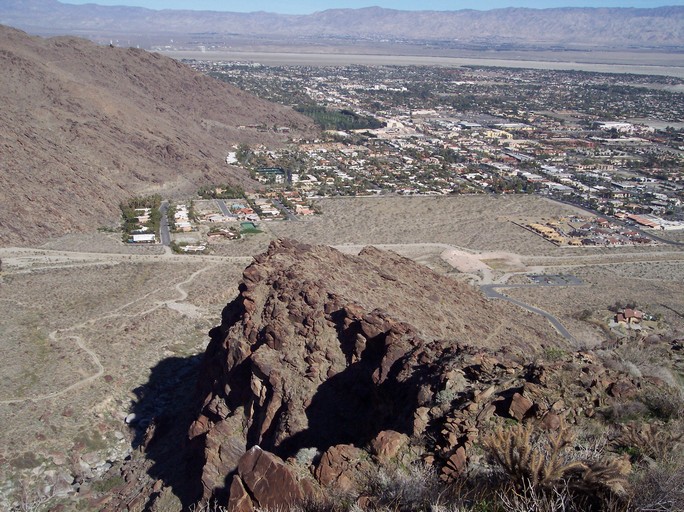
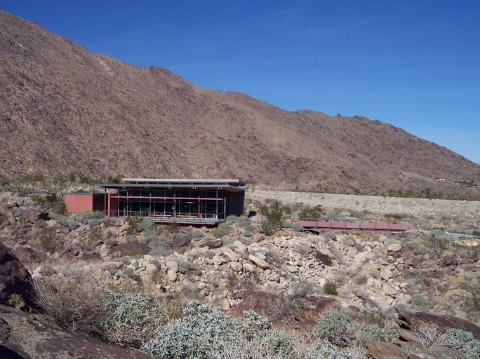
Palm Springs from the South Lykken. All Photos by: Gary R. Burzell 3.5 Miles Moderate Difficulty Beginning Elevation is 560' with an elevation gain of 900' Directions: The north end of this trail starts at the end of Mesquite Road. You will have to park down by the Chevy dealer and walk to the trailhead. There is a new Tahquitz Canyon visitors center being built at the end of the road, but I don't know at this time if you can park there to hike the Lykken trail. As you walk up Mesquite you will pass a mobile home park on the left, and a big house on the right. Continue up the road, and the Lykken trail will start up the mountain shortly after the road turns right toward the Visitors Center. The south end of this trail is accessed
by going up South Palm Canyon Drive about 1 1/2 miles south of Highway
111. You know you are there when you pass the last of the condos and
houses on the right.
This is one of my favorite trails. It was the first trail I hiked in Palm Springs. There are picnic tables at both north and south end of this trail (although the tables at the north end have been vandalized recently and are in pretty bad shape...). We usually start and the north end of this trail and climb up to the picnic tables at the top of the trail. This is a moderate hike, and will take you about 40-45 minutes at a medium pace. From there, you can turn around and go back, or continue on to the south end of the trail (If you do this, leave a shuttle car at the south end of the trail). If you choose to do this the trail is mostly downhill from the picnic tables if you are going from the north end to the south end, and the hike will take about two hours. Sometimes to make the hike a little more difficult we will start at the south end and hike to the north end. When you hike the north end of this trail, you will be rewarded with fantastic views of Palm Springs, the Coachella Valley, and down into Tahquitz Canyon. If you have never hiked in the Palm Springs area, do this one first. You will not be sorry you did.
View of Palm Springs from the South Lykken
A cross at the top, and a photo of the Tahquitz Canyon Visitors Center.
Where to park by the Chevy Dealer, and the road leading up to the trail.
For tips on how much WATER you need click above
Hiking Message Board If you find this hiking information useful, and would like to use PayPal to help us with the costs of this website, you can donate any amount you want ( $1, or $5, or maybe $56,000 -- err aah, ok that may be a bit much, however any amount you want to send helps a lot . . . ) just by clicking the logo above! Please note this is not necessary or expected, but any amount helps us keep improving this Website ! !

FastCounter by bCentral Website designed and maintained By:
|